NATURE PARK BIOKOVO IS OPEN FOR VISITING. TICKETS ARE AVAILABLE ON THE WEB STORE.

Geological-paleontological heritage

Biokovo is a part of the Dinaric Mountains and as such has a direction of NW-SE.

Geology of Biokovo

The geology of Biokovo cannot be viewed only within the borders of Nature Park. It must be seen in a comprehensive and complex manner. At the end of the Cretaceous era, about 65 million years ago, the African plate began colliding with the Eurasian plate. The narrowing of
the ocean caused strong tectonic disturbances, making the horizontal layers crinkle, break and emerge above the sea surface, forming mountain ranges like the Alps and the Dinarides, which Biokovo belongs to. In this way the ancient ocean Tethys has largely disappeared and
its remains is today's Mediterranean Sea.

Biokovo is a part of the Dinaric Mountains and as such has a direction of NW-SE. The material in the lower parts towards the sea and on the opposite Zagorje side is mainly made up of Eocene Flysch sediments while the higher parts are shaped into carbonate sedimentary rocks. The base of the central part of Biokovo is a slightly tilted plateau which rises from the sea to a height of approximately 300 m, and since it is formed mainly in the Flysch sediments, it is fertile and green. That “green belt” is continued as the most impressive part of the rocks
that rises to a height of about 1000 m and as a facade it separates Zagora from the coastal area. On the top of these rocks is a view of a region that has the shape of a wavey plateau and is 3-4 km wide, characterized as a richly developed karst relief and it slowly and gently
lowers itself towards the hinterland.

Geological construction and composition

As at first sight on Biokovo where there are differences in the appearance of certain parts of the mountain, there are also three basic units for the stratigraphic-structural characteristics of rocks.

1. Coastal belt

The area leading to the mountain is made up of deposits of Upper Cretaceous (Senonian), while it is dominated by Tertiary and Quaternary sediments. Within the Cretaceous sediments the most abundant are Senonian rudist limestones, which are generally bulky, light gray parts of dolomite and are found in the narrow area above the tope of Dubac to Basta and then again above Promajna and ove the shell. The Tertiary is represented mainly by weakly-layered foraminiferal limestones, whose main rock mass often build fossils of alveoline and nummulites, then calcareous breccias, which are poorly layered, light brown to gray, and predominantly with large fragments of micro-cristal calcite and fragments of fossil remains. These deposits are found in the wider area of the Krvavica, across Makarska through Gornji Tučepi. Fleece is prevalent along the coastal area, and it is built by sandstones and limestones alternating with marls. According to petrological characteristics they are classified as calcirudite, calcarenites, and marls. The appearance of Quaternary sediments is related to the slopy gravitational processes on a steep mountain slope, which through occasional strong currents affect the rapid transport of material and its deposition in the foot. These processes, washing and gullying, influenced the creation of deluvial and proluvial talus deposits (breccia), which are found along the coastal belt. The action of waves and currents that devastated breccias, rounded their fragments, transported, and deposited them on the shore created another type of Quaternary sediments, which are sandy beaches, thanks to which the Makarska Riviera is widely known.

2. The central mountain ridge of Biokovo is made of rock complexes from the Jurassic and Cretaceous (Mesozoic) period. Plaques were developed in a continuous sequence of carbonate sedimentation (with local Albian emergence) of Liassic to Senonian. They are represented by shallow water carbonate sediments of littoral features, which were deposited under conditions of extensive carbonate platforms. These are limestone with dolomite lenses of Lower Jurassic age, thickly layered and bulky limestone Dogger (Middle Jurassic), thickly layered limestone oolitični Malmo (Upper Jurassic) and dolomite, dolomite limestone, limestone breccia and Cretaceous age.

3. The Biokovo hinterland is formed in Cretaceous-Paleocene carbonate-clastic sediments. Here is a thick series of sediments fliških rocks are characterized by regular changes of larger and smaller detritus of breccia, sandstone, marl and marly limestones.

Tectonic structure and relation

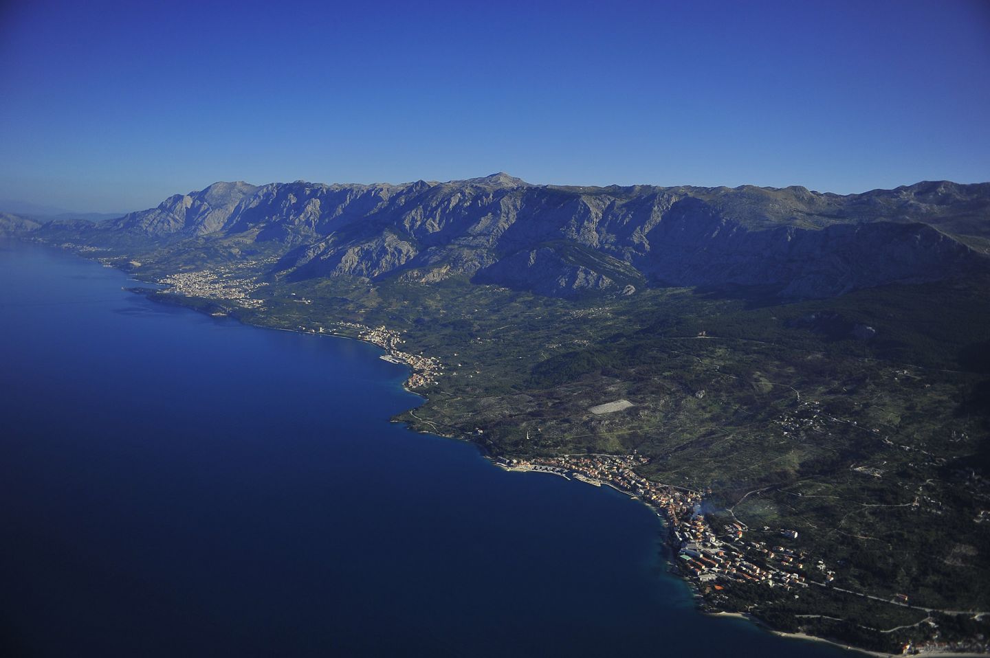
In geomorphologic terms, mountainous ridge of Biokovo is shaped in tectonically very broken Mesozoic carbonate rocks (NW-SE). It is expanded along the lines of Vrulja (Dubci) - Šestanovac to the Neretva River in the southeast and forms the border between the regional structures. In geotectonic terms the zone belongs to the Outer Dinarides. The south-western part of the structure of Biokovo is drawn (or reverse fitting) to the intensely folded flysch sediments, which are abundant in the vast area of the sea cliffs of Biokovo. There are three tectonic units:

1. The tectonic unit of the Makarska coastal area is limited on the northeastern the the cover of Biokovo, while the southwestern side is covered mostly by sea. Basically it is a native Flysch displacement built from a series of elongated and overturned pine trees, often presječenih normal faults and large cracks. Lithologically speaking, the basis of these units are heterogeneous flysch sediments of varying strength and plasticity. Moving from the coast towards the front cover of Biokovo, one can distinguish several incoherent elongated fold system - shells, with a steep south-western and northeastern mild wings. The basic characteristics of these tectonic units are folds, transferred folds, laid folds and shells, and are the result of this are the covering of Biokovoe with flysch sediments in the foreland.

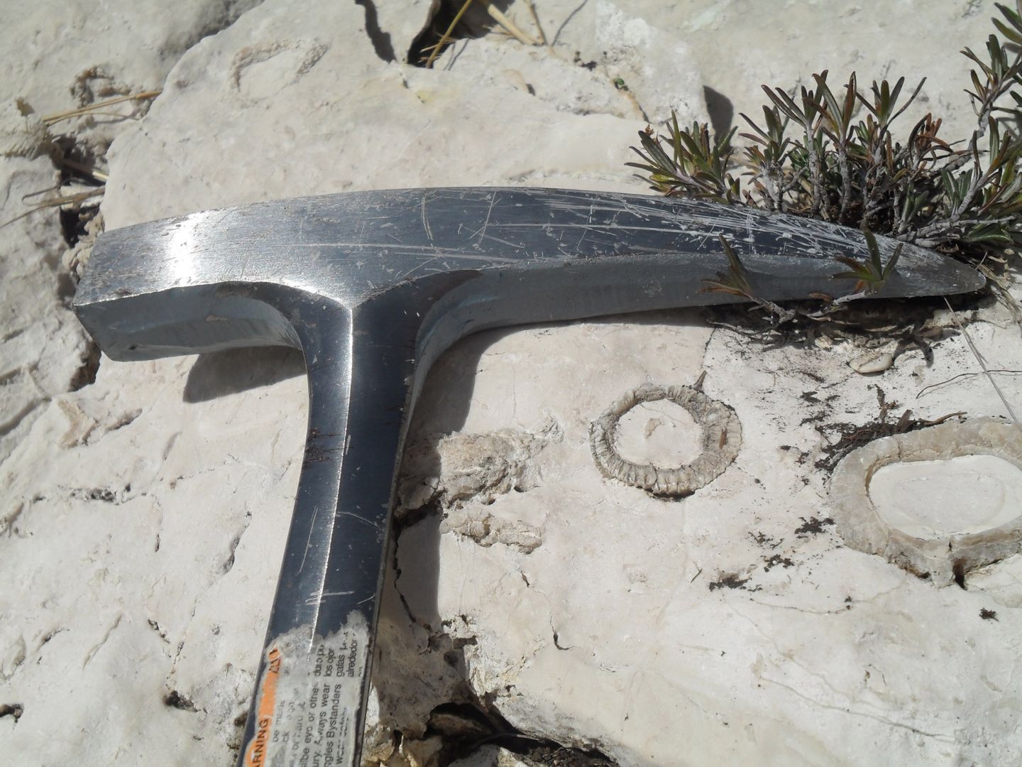
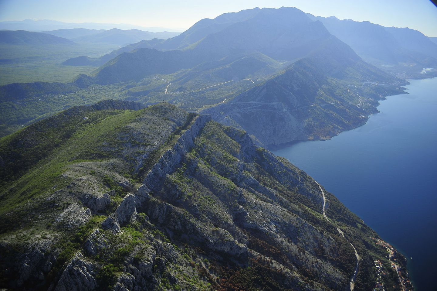
2. The tectonic unit Biokovo covers a vast area of the prominent ridge with very steep southwest and relatively gentle northeast slopes. It is composed of folded and tectonically fragmented complexes of Mesozoic carbonate rocks. At the end of the upper Cretaceous, within the Laramian orogeny, the tectonic evolution of the cover of Biokovo started. With the constant activity of tectonic movements orogenetskih various stages, first the mass starts compressing, then the orientation (NW-SE), forming of the shell, partly laid folds and at the end the cover. The entire length of the drawn surface mass of Biokovo is made of flysch. One of the characteristics of this tectonic unit is the high degree of tectonic disturbance. In addition to the cover and subsequening folds, there are a series of vertical and subvertical  faults in the general direction S-SW, S-SE. These faults are the result of non-uniform stresses in the structure of Biokovo during its transformation to a cover and are also among the oldest faults of Biokovo.

3. The tectonic unit Biokovo hinterland is part of the special hinterland of Biokovo, and the basic structural characteristics of the terrain is a scaly structure. It consists of a series of overturned anticlines built by Cretaceous carbonates, which are drawn along the reversed reduced southwest wing of flysch and foraminiferal limestones. Recent radial movements, although present, did not change the basic appearance of the scaly structure of this tectonic unit.

In the area of Biokovo is an area of recently active and the structurally most important fault called Mosor- Biokovo. The relief is characterized by prominent cliffs. The fault Zagvozd- Vrgorac-Metković, is separated by smaller structural units and the mountain Biokovo hinterland and is largely emphasized in the relief precipice, whose height exceeds 500 meters in some places in the hanging wall of faults. Biokovo is in one of those areas in Croatia which is emphasized with seismic activity. Biokovo’s epicentral area (42.5 ° - 44.0 ° north latitude, 16.4 ° - 17.5 ° IGD) is part of a narrow band of increased seismic activity, which stretches along the coast, and the earthquakes that occur here are the result of tectonic processes occurring at the border confrontation of the Adriatic basin and the Dinarides, where the main direction of thrust is towards the coast. More distinctive places of increased seismic activity are intersections and especially the places where there is a larger convergence of faults. Earthquakes are at various depths, but they are all above Mohoro’s discontinuity, which is based on geophysical and geodetic data calculated for this area, and is about 40 km along the slope surface towards S-SE.

Geomorphological features

All of the so far registered geological, geomorphological, tectonic and speleological relations indicate the complexity of the morphology of the mountainous terrain of Biokovo. Looking at the karst relief in general, it can be divided into two types of karst forms: exogenous and endogenous. Exogenous forms of karst features are formed on the surface and on Biokovo they are dolines (sinkholes), the bay and cracks.

Dolines or sinkholes

Sinkholes or dolines are a typical shape of the karst areas. These are depressions in the karst which are generally circular to sub circular in shape and a few meters to about one kilometer in diameter. The sides of the sinkholes range from mild to vertical slopes and deep as a few meters to several hundred meters. In the central part of Biokovo they appear as densely packed groups that dominate the terrain and look like craters on the lunar surface or so-called reticulate debris. Given the way they were created, we can distinguish between two basic types of sinkholes. One type of sinkholes are caused by corrosion-like gouging of the surface. During the dissolution of limestone, insoluble residue was left behind in the form of red soil. The second type are sinkholes formed by the collapsing of ceilings of large underground cavities. Besides these two basic mechanisms for the creation of sinkholes in nature, there are a number of transitional forms of corrosion processes where limestone and collapsing into underground cavities operate simultaneously and are mutually complementary. The process of corrosion of end portions of shallow sinkholes connected by create elongated depressions with long shapes – bays.

Cracks

Cracks in geologic time are very young microforms on the surface relief. They are generated by water on the bare limestone rocks under a certain inclination. These are narrow gutter-like forms with a depth of mostly 0.1-1 m and separated by sharp or rounded edges. They can be flat if the surface rocks in which they are created are steep or wining with smaller inclinations.

Stone holes

Stone holes occur on small slopes or horizontal surfaces. The most common sizes are from several centimeters to one meter in diameter. In the beginning there are a fewer cavities that contain water, which gradually dissolves the limestone. Their origin may be of corrosion - caused by the action of rainwater on limestone and biogenics – and are formed when smaller depressions in carbonate rock fill of organic material, which dissolves the rock through biochemical processes.

Caves

Endogenous forms of karst features are formed underground, and the mountain ridge of Biokovo are pits and caves. Caves are underground spaces of different sizes and shapes that often occur by the expansion of horizontal or slightly inclined cracks or boundaries between layers of sedimentary rocks. In the origin of caves, the water flows enriched with carbon dioxide have a crucial role, which sink from the surface into the underground following the cracks in the soluble rock rubble. The water dissolves limestone chemically and mechanically breaks off and carries away rock particles. This creates all the spacious halls and underground channels. Mineral deposits formed in pits and caves are called speleothems. The term refers to a characteristic occurance with limestone in caves and holes and does not mark the mineral itself. The most common and most important deposits in caves are many calcite speleothems. Its growth can fit in and catch the traces of many other minerals, poplavnogog detritus, dust from the air, and various organic materials. The form of speleothems depends mostly on their creation. Stalactites and stalagmites are vertically elongated in the direction of dripping water. Stalactites grow from the ceiling to the floor of the cave, stalagmites and vice versa - from floor to ceiling. When a stalagmite grows to connect with stalactites, a pillar is formed that can reach large dimensions. There are other very common speleothems. They arise from the slow crystallization of a thin film of water that flows in a wide area and their shape depends on the substrate on which they arise. Very often the ornaments cave curtains and cascades (stone holes).

Pits

Pits are depressions with steep vertical sides and often a smaller diameter and great depth. 

The Biokovo amfora pit is currently fourth on the depth of pits in Croatia. It was discovered in 1998 by cavers from the speleological-alpine club Ekstrem. It has been excavated to a depth of 788 meters. In the area of the Nature Park Biokovo 177 caves have been investigated so far, and there are 33 known unexplored caves. Further investigations are continuing.

The tectonic evolution shows that mezozoijske sediments even before the deposition of Eocene sediments were influenced by the karstification process and that the youngest movements did not significantly impacted the basic structure, but only intensified their intense fragmentation. The relief thus formed was followed by the impact of Pleistocene ice sheets on which its present-day climate and specificity continues.

Paleontological findings

Numerous fossils from younger geologic periods were found in the Biokovo caves and pits. Paleontological sites for the faun community Vertebrate are from the lower Pleistocene and Upper Pleistocene age.

When building the Makarska - Zadvarje road to the Dubci pass, a site was cut off where most of multilayer fosilifernih breccias was located and was formed by the tectonic contact between the Upper Cretaceous limestone and Eocene flysch marl. Paleontological analysis of animal bones and teeth collected from breccias showed that faun community at the Dubci site consisted of 29 faunskih elements, making it the richest faun community in the Dinaric karst. Fauna consists of steppe and forest types, indicating that there was was a steppe landscape during the formation of breccias in the Dubci area where there were fewer trees and groves. The fauna mostly represented by the Etruscan bear and rhino, forest elephant, etruscan cattle and othes. Fossils were found from the lower Pleistocene age.

In the Baba cave which is located in the northeastern part of Biokovo, shaped in thick layers of Upper Cretaceous limestone, fossils are found from the upper Pleistocene period when the cave was used many generations by cave bear (Ursus spelaeus) for shelter. The side walls and stone blocks have so-called bear drillings which are created by pulling, scratching and the friction of thebear body on hard rocks around the nest. Rounding and smoothing these rocks allow the clay, sand and other minerals, which have entered the bear's fur during their passage through the cave. In addition to these findings, fossilized remains of brown bears (Ursus arctos), wolf (Canis lupus), the skeletal remains of chamois (Rupicapra Rupicapra) and ibex (Capra ibex), subspecies of snow hare (Lepus timidus), alpine marmot (Marmota Marmota), snow mouse (Microtus nivalis) and the skeletal remains of mountain voles (Dolomys sp.) were also found.

Fossil remains of red deer (Cervus elaphus) dating from the upper Pleistocene period – lower Holocene, and were found in the pit Snježnica northwest tip of St. Jure (1762 m) and in the Jelenjoj pit north of the Vošac peak (1422 m).

Hydrography

The karst relief in addition to exogenous and endogenous appearance and form is characteristic in its hydrography as well. The Biokovo ridge is formed in limestones, which are watertight. After rain falls on limestone, the water partially sinks, the other part flows, a third evaporates. Water that collects in the ground when flowing encounters a Flysch barrier that does not leak or leaks very little. Therefore, the contact of Cretaceous limestone and Eocene flysch along the Makarska Riviera created a number of sources, some of which streams flow towards the sea. These springs and streams are abundant in the period of melting snow on Biokovo, while one part dries up during the summer.

When there is contact of limestone and flysch rocks on the seafloor, or in places where limestone rocks reach the sea, the water comes out at the sea bottom in the form of freshwater sources – submarine springs. This phenomenon of karst hydrography is observed on the surface especially in autumn, winter and spring. One of the largest and most famous submarine springs in the Adriatic Sea, located on the site "Vrulja" between Pisak and Brela. The spring complex that emerges around the rim of the bay can be seen from the Dubci saddle (288 m), where the steep Biokovo rocks crash into the sea. Along the Makarska Riviera there are submarine springs between Podgora and Drašnica - Mala Vrulja and Klokun, and in the bay at Žrnovnica next to Gradac.

Due to the scarcity of spring water, people on Biokovo mostly did and still refer to the rainwater that is collected in a variety of less permeable surface depressions which were created in natural (ponds, oysters) or artificially (wells) ways.

In the past, the water supply on Biokovo had great significance in ice caves where the ice remains throughout the year. Poor populations extracted ice from these caves and passed them on donkeys to the coast for tourism purposes (eg, Stara ledenica pit).